The Indonesian island of Lombok is Bali’s calmer cousin, but it still draws plenty of winter warmth seekers, summertime beach lovers, and year-round surfers. But Lombok’s appeal goes far beyond sand and sea – inland are wonderful waterfalls, villages rich in culture, and the soaring slopes of Gunung Rinjani, Indonesia’s second biggest volcano.
For many travelers, the climb up Gunung Rinjani is a reason to visit Lombok all by itself. Soaring to 3726m (12,224ft), this active volcano dominates the northern half of Lombok, towering over the surrounding landscape like a real-life Mount Doom.
In fact, the volcano erupts only occasionally, with the last eruption – a small ejection of ash from the Barujari cone – in 2016. While seismologists monitor Rinjani year-round, the peak is usually safe to climb, with the classic route from Senaru or Sembalun taking two or three days. With epic views, the ascent is one of the most rewarding things to do in Indonesia.
Advertisement
Local guides are highly experienced at leading hikers to the summit, and in high season, it’s possible to rock up and join a trek without too much advance planning, though you’ll need to bring comfortable hiking shoes or boots and warm layers for the cooler weather at the summit and crater rim.
Here’s everything you need to know to get more from your trek up Gunung Rinjani.
When should I go to Gunung Rinjani?
Climbing Gunung Rinjani is not permitted from 1 January to 31 March, and while that may sound like a big chunk of time, this coincides with the dampest months of the rainy season on Lombok. With the steep trails and loose material underfoot, you don’t want to be climbing this rugged peak in potentially dangerous weather.
The April to November dry season is the best time to attempt the climb, and finding a guide is quite easy in the high season. Escorting tourists up Gunung Rinjani accounts for a large part of the local economy, and you should be able to join a trek without too much advance notice during the dry months.

How much time should I spend at Gunung Rinjani?
This partly depends on where you climb from. The vast majority of treks begin from the towns of Senaru or Sembalun, from where the trek takes two to three days, with overnight camping stops on the way. You can also start from Tetebatu on the mountain’s southern slope, just an hour from Lombok International Airport at Mataram. You’ll meet far fewer hikers and you can reach the summit in a two-day, one-night ascent.
What’s the best way to see Gunung Rinjani?
Officially, everyone climbing Gunung Rinjani should go with a guide, and as this is an active volcano, we advise against attempting the hike without one. Should there be a problem on the mountain – as happened in 2016, when a small eruption of the Barujari cone led to tourists being evacuated – you don’t want to be on your own and off the radar of rescue workers.
You can explore Gunung Rinjani on a two-day, one-night hike, but to reach the true summit, high above the mighty Rinjani crater, you’ll need to join a three-day, two-night hike. Having put in the effort to scramble uphill over rocks and cinders to reach the rim, it would be a waste to turn back without continuing to Lombok’s highest point, and this will also give you a chance to enjoy the hot springs inside the crater.

How much does the Gunung Rinjani trek cost?
The entry fee for Gunung Rinjani National Park is 200,000Rp (US$12.20) per person per day, and this is usually included in the cost of an organized trek. The price of the trek will also include fees for your guide and support staff, food for the duration of the trek, and tent accommodation.
Expect to pay around US$170 per person for a two-day hike – perhaps less if there are more people in your group, or more if there are just a few of you. Trips lasting three or four days cost more, as the organizers have higher costs for food and staff.
Advertisement
You can arrange the trek through tour agencies, homestays or hotels in Senaru, Sembalun or Tetebatu, or before you come to the area in Mataram or tourist hangouts around the coast.
What should I eat and drink on a Gunung Rinjani hike?
If you come on an organized hike, your meals will be provided, often with snacks such as fresh fruit to keep you going on the trails. Menus tend to be filling and nourishing rather than adventurous – fried rice, fried noodles and noodle soups are popular, with eggs or chicken as protein, cooked at simple camp kitchens.
Guides will supply drinking water, but there’s no harm in bringing a reusable water bottle and water purification tablets or a water filter so you can top up at natural water sources along the trails. Bring any snacks and treats you need from the trailheads.

What are the top things to see and do?
Clocking in at an impressive 3726m (12,224ft), Indonesia’s second-highest mountain is both mighty and revered. Gunung Rinjani is sacred for both the Sasak people and the island’s Hindu population, and the summit is a popular pilgrimage site.
For those less spiritually inclined, the strenuous hike to the volcano’s summit is one of Indonesia’s most spectacular experiences. It isn’t for the fainthearted, but the incredible views are among some of Indonesia’s most lauded.
Depending on how long you hike for, you can gaze across the Rinjani crater and caldera lake, bathe in hot springs, camp in front of dramatic mountain views, or reach the highest point on Lombok – and feel utterly connected to the powerful geological forces that shaped the island.
The Gunung Rinjani hike
After departing from Senaru or Sembalun – or Tetebatu, if you’re so inclined – the trails that wind up the flanks of Gunung Rinjani climb through grassy savannah and areas of rainforest teeming with wildlife. All the routes are challenging, but well frequented – including by less experienced hikers. That said, the walk is no gentle stroll in the park; this is a real trek, with steep ascents over uneven ground and loose rocks and volcanic cinders.
The crater rim
Less ambitious hikers can hike for two days and one night to reach – and finish at – the crater rim at around 2640m (8661ft). As the landscape shifts from lush to arid, the terrain opens up to reveal panoramic views looking out from Rinjani across the foothills towards the coast, and views into the plunging crater from the rim.
You’ll get an eagle’s eye view over deep blue Danau Segara Anak and the cinder cones at the bottom of the Rinjani caldera, and you can snap photos to wow the folks back home in all directions, but the true summit lies a day’s hike further along the crater rim.

The summit
Having reached the crater rim, you’ll have to continue around the rim of the enormous Rinjani caldera to reach the tip of the mountain. Loose rocks, soft ground and a steep gradient define the final grueling stretch to the summit. The views from the summit are nothing short of staggering, revealing the crater in all its glory below, and the rest of the island beyond.
The trek to the top of this prized peak takes a minimum of three days and two nights, with the first and second night spent camping along the crater rim. Most hiking groups begin walking on the second day before sunrise so they can reach the summit at dawn, as the landscape emerges dramatically from the mists.
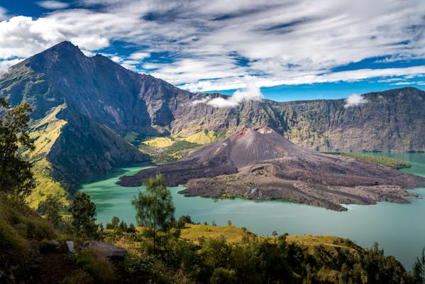
Danau Segara Anak and the hot springs
Crescent-shaped and cobalt blue Danau Segara Anak is a huge volcanic lake to the west of Gunung Rinjani’s attention-grabbing summit, just below the crater rim. The word danau means “lake” and segara anak means “child of the sea” – alluding to the lake’s similarities to an inland ocean. At the lake’s eastern end, the Barujari cinder cone was the site of the most recent eruption in 2016.
If you decide on a three-day or four-day hike, you’ll have the opportunity to head down into the crater to enjoy the natural hot springs that bubble up beside Danau Segara Anak. It takes two hours to reach these natural pools, descending through ethereal low-hanging clouds, and you can soak in the springs on arrival (bring your swimsuit). The hot thermal waters flowing from the Surya Sakti waterfall make for a particularly picturesque scene.

The Rinjani foothills
Guided walking tours from Senaru into the foothills of Gunung Rinjani offer deeper insights into the region’s flora and fauna, as well as the traditions and farming techniques of the Sasak people. Women-owned and operated, trek and tour company Rinjani Women Adventure specializes in introducing travelers to the area and its culture.
Their half-day Senaru Panorama Walk, led by local women, meanders through small villages and rice terraces. You’ll traverse irrigation channels bordered by bamboo groves, before ending up at Sendang Gile, a gorgeous waterfall nestled in the jungle. Most homestays in the Gunung Rinjani area can connect you with a local guide for tours around the foothills.
Bukit Selong and Pergasingan Hill
For a different perspective on Gunung Rinjani with less effort involved, you can view the volcano from the lookout at Bukit Selong near Sembalun. A gentle, one-hour hike will take you to a small hill overlooking a vast stretch of fields backed by a brooding mountain to the east, and the rooftops of Sembalun and Gunung Rinjani to the west. There’s a 10,000Rp (US$0.60) entry fee.
Alternatively, try the walk to Pergasingan Hill to the north of Sembalun. The ascent is often completed at sunrise, leading to sweeping views of the entire Sembalun Valley, plus the entirety of Gunung Rinjani in the distance.
The walk provides an impressive overview of Lombok’s volcanic terrain, and you can reach the top in around two hours, depending on how much time you spend oohing and ahhing at the views on the way. Entry to the trail costs 50,000Rp (US$3).
Is Gunung Rinjani accessible?
With the rocky, loose terrain and steep ascents, you’ll need to be reasonably fit and agile to climb Gunung Rinjani. There are no routes to the crater rim or summit that are accessible to visitors with limited mobility.
This article was adapted from Lonely Planet’s Indonesia guidebook, published in July 2024.